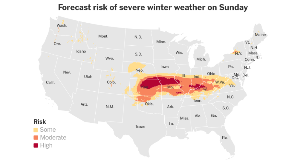
A fierce storm heading towards the Mid-Atlantic States brought wintry weather including sleet, snow, and freezing rain, causing significant disruptions to daily life and travel. The storm impacted a vast area stretching more than 1,500 miles across a dozen states, affecting around 50 million people with winter weather advisories, watches, and warnings. Power outages and travel disruptions were likely, with up to 5,000 people without power in Kansas. States such as Arkansas, Kansas, Kentucky, Missouri, and Virginia declared states of emergency to enhance their responses to the storm.
The storm coincided with the arrival of Arctic air from Canada, leading to brutally cold temperatures behind the storm as it moved offshore. Some areas were expected to receive their heaviest snowfall in a decade, with nearly four million people in Kansas, Missouri, and Nebraska under a blizzard warning. Motorists faced hazardous conditions on roads, with reports of highway crashes and a snowplow flipping over on an icy road. Interstate closures and limited hotel occupancy due to cancellations were common, and residents braced for the challenges posed by the storm.
The storm was forecasted to push through the Central Plains and mid-Mississippi Valley into the Ohio Valley, with heavy snow expected in an area spanning from northeast Missouri to the central Appalachians. Southern Illinois and Indiana were predicted to receive sleet and freezing rain, while Ohio prepared to deploy over 1,000 snowplows to tackle the storm. Freezing rain was expected in regions from central Kansas to the central Appalachians, with potential ice accumulations exceeding half an inch. The system was set to move into the Mid-Atlantic, bringing rain and thunderstorms to parts of the lower Mississippi Valley.
By Monday, snow was expected across the Mid-Atlantic region including Delaware, Maryland, Virginia, and Washington D.C., with Baltimore forecast to receive four to nine inches of snow and Washington five to nine inches. The system’s exact track could affect snowfall totals, with adjustments possible based on slight shifts north or south. Cold, gusty weather was anticipated for the week ahead, with below-average temperatures stretching from the eastern Rockies to the East Coast. After the storm passed, some areas might see lingering light snow, while the Midwest prepared for icy conditions from sleet and freezing rain.
With states like Indiana activating the National Guard for highway rescues and preparations escalating in the face of the storm, the severe weather posed a significant threat to communities in its path. As residents across the impacted regions braced themselves for power outages, travel disruptions, and treacherous road conditions, emergency response teams and state officials worked to minimize the storm’s impact and keep residents safe. From blizzard warnings to freezing rain and potential flooding from heavy rain, the storm’s wide-ranging effects highlighted the importance of preparedness and caution in the face of extreme weather events.


