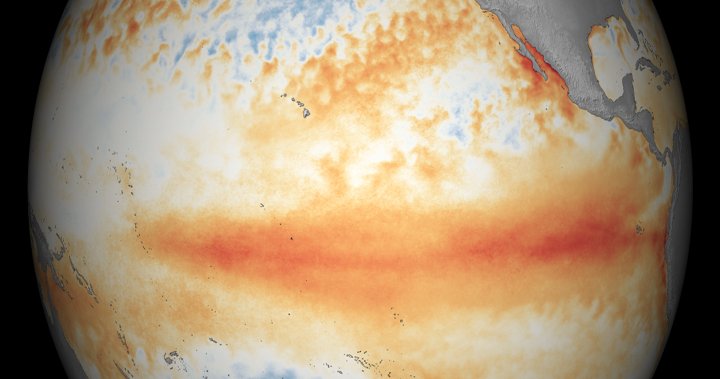
The El Niño weather event that has been affecting the Pacific Ocean and the world may finally be coming to an end, according to scientists. As the sea surface temperatures in the Pacific have been cooling since December, it is likely that the El Niño phase is over and the switch to a neutral phase, known as the El Niño-Southern Oscillation (ENSO), will occur until at least July. This transition indicates that the cooler La Niña phase may be on the horizon, bringing colder effects such as greater precipitation and winds, which could lead to rainstorms and more hurricanes.
While the impacts of El Niño on Canada have been evident in the warmer temperatures and reduced snowfall during the winter, it is expected that the transition to La Niña may not immediately result in significant widespread weather changes. Instead, Canadians may experience more localized weather events like thunderstorms. However, in Western Canada, the lingering dry conditions from El Niño may contribute to an increased risk of wildfires during the summer months. Additionally, the combination of increasing greenhouse gas concentrations in the atmosphere and El Niño has contributed to record-breaking temperatures in Canada in recent months.
Looking ahead, Canada may see a return to slightly cooler temperatures as La Niña is anticipated to take effect in the next year. While there is a forecast indicating a 60 percent chance of La Niña developing over the summer, there is still uncertainty regarding the exact impacts it may bring. La Niña has the potential to result in a more active hurricane season in Atlantic Canada due to reduced wind shear and warmer sea-surface temperatures. The effects of La Niña’s colder temperatures will likely be felt more noticeably during the winter months, with expectations of chillier conditions in the Prairies and a colder, wetter winter in British Columbia and Eastern Canada.
Despite the potential for La Niña to usher in colder and wetter conditions in different parts of Canada, there is still uncertainty surrounding the duration and intensity of this weather event. While the transition from El Niño to La Niña may lead to changes in local weather patterns, the full extent of these effects will likely not be fully realized until the winter months. It is important to note that weather forecasts and predictions regarding the impacts of La Niña are subject to change, and additional factors such as wind direction and deep water temperatures must be considered in assessing the full impact of these weather events.
In the coming months, Canadians can expect to see the lingering effects of El Niño persist in certain regions, particularly in Western Canada where dry conditions may contribute to an increased risk of wildfires. While the transition to La Niña may bring about changes in weather patterns, it is important to remain cautious in interpreting these forecasts as the unpredictability of weather events can lead to unexpected outcomes. Overall, the fluctuation between El Niño and La Niña phases underscores the complex and interconnected relationship between ocean temperatures, atmospheric conditions, and global climate patterns, highlighting the need for ongoing research and monitoring to better understand and respond to these weather phenomena.


